Around the bend

Skip to Videos
  • Big Creek Trail Loop - a waterfall hike for all seasons
    • 9/5/22

    Big Creek Trail Loop - a waterfall hike for all seasons

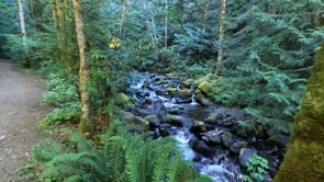
    Starting from the Big Creek Campground, follow the Upper Big Creek Loop Trail to Big Creek and the first of several sturdy bridges along the way. After a short climb you’ll reach the Creek Confluence Trail which drops to the confluence of the tumbling Big and North Branch Creeks.

  • Murhut Falls
    • 8/2/22

    Murhut Falls

    Hidden in a lush narrow ravine and once accessed by a treacherous path, Murhut Falls were long unknown to many in the outside world. But now a well-built trail allows hikers of all ages and abilities to admire this beautiful 130-foot two-tiered waterfall. The trail starts by following an old well-graded logging road. It was past logging in this area that led to the discovery of these falls.

  • Rocky Brook Falls
    • 7/27/22

    Rocky Brook Falls

    Dosewallips River Valley
    Directions: From Brinnon at Milepost 306 on US 101, drive west on the Dosewallips Road for 3 miles to parking in turnout on your left just after bridge over Rocky Brook
    Ownership: Private
    Distance: .25 mile roundtrip
    Difficulty: easy
    No pass
    Kid-friendly, Dog-friendly (on leash)

    One of the tallest waterfalls on the Peninsula, Rocky Brook Falls is also among the prettiest. Follow the trail past a small hydroelectric generating building and come to the base of the stunning towering falls fanning over ledges into a large splash pool surrounded by boulders. This classic horsetail waterfall crashes more than 200 feet from a small hanging valley above.

    While a penstock diverts water from the brook for electricity production, the flow over the falls is almost always pretty strong. Like all waterfalls, these too are especially impressive during periods of heavy rainfall. On warm summer days the falls become a popular destination for folks seeking some heat relief.

    This classic horsetail waterfall crashes more than 200 feet from a small hanging valley above.
    And while many waterways east of the Mississippi River are called brooks, creek is the preferred name in the west. There are only a few waterways on the Peninsula called brooks, and they were more than likely named by someone who hailed from back east.


    Details and directions at: https://www.waterfalltrail.org/waterfalls-1/rocky-brook-falls
  • Following the Olympic Peninsula Waterfall Trail | Porter Falls
    • 7/9/22

    Following the Olympic Peninsula Waterfall Trail | Porter Falls

    Recently Jeff Slakey and his mother checked out a local waterfall – Porter Falls in the Capital Forest. Located at the confluence of the South and West Forks of Porter Creek, here one branch cuts through a cleft while the other plunges over ledge into a big punchbowl. Follow a quiet trail through stately moss-covered trees to a small hidden rocky chasm to view them.
    The trail leads through dark forest and begins climbing. It then traverses a steep slope before descending and coming upon the South Fork Porter Creek. The trail then comes up along the tumbling West Branch Porter Creek. Continue to the confluence of the two branches and Porter Falls. The West Fork plunges into a basaltic punchbowl basin while the South Fork careens through a tight basaltic chasm. 

    Details & Directions: https://www.waterfalltrail.org/waterfalls-1/porter-falls

    Distance: 1.6 mile roundtrip
    Difficulty: easy
    Discover Pass required
    Kid-friendly, Dog friendly (on leash)